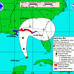
At 9:00 pm, CST, a hurricane warning was issued for the Northern Gulf Coast from Pascagoula Mississippi Eastward to Indian Pass Florida. A hurricane warning means that hurricane conditions are expected somewhere within the warning area within 24 hours. Preparations to protect life and property should be rushed to completion.
 At 9:00 pm, CST, a tropical storm warning and a hurricane watch are in effect for the Northern Gulf Coast from Grand Isle Louisiana Eastward to West of Pascagoula Mississippi including New Orleans and Lake Pontchartrain. A tropical storm warning means that tropical storm conditions are expected somewhere within the warning area within 24 hours. A hurricane watch means that hurricane conditions are possible within the watch area, generally within 36 hours.
At 9:00 pm, cst, a tropical storm warning has been issued for the Northern Gulf Coast from East to Indian Pass to Aucilla River, Florida.
At 9:00 pm, CST, the Government of Cuba has discontinued all watches and warnings for Cuba.
At 9:00 pm, CST, the center of Hurricane IDA was located near latitude 23.7 North, longitude 86.7 West or about 400 miles South-Southeast of the mouth of the Mississippi River
Ida is moving toward the North-Northwest near 14 mph. A turn toward the North and an increase in forward speed are expected during the next 24 hours, followed by a turn toward the Northeast on Monday night. On the forecast track. IDA is expected to cross the Gulf of Mexico tonight and Monday and approach the Northern Gulf Coast Monday night or early Tuesday.
Maximum sustained winds are near 105 mph with higher gusts. IDA is a Category 2 hurricane on the Saffir-Simpson Scale. Gradual weakening is forecast, but IDA is expected to remain a hurricane as it approaches the Northern Gulf Coast.
Hurricane force winds extend outward up to 35 miles from the center and tropical storm force winds extend outward up to 175 miles.
Ida is expected to produce additional rain accumulations of 1 to 3 inches over portions of Western Cuba, with isolated maximum storm total amounts of 8 inches possible.
Rains will be increasing well in advance of IDA across the Central and Eastern Gulf Coast, but will become steadier and heavier by Monday into Tuesday. Total storm accumulations of 3 to 5 inches with isolated maximum storm totals of 8 inches will be possible through Tuesday from the Central and Eastern Gulf Coast Northward into the Eastern portions of the Tennessee Valley and the Southern Appalachians.
A dangerous storm surge will raise water levels by as much as 4 to 6 feet above ground level along the coast near and to the east of where the center makes landfall. Near the coast the surge will be accompanied by large and destructive waves.
Summary of 9:00 pm, cst information:
Location…23.7N 86.7W
Maximum sustained winds…105 mph
Present movement, North-Northwest or 345 degrees at 14 mph
Minimum Central pressure…979 MB


