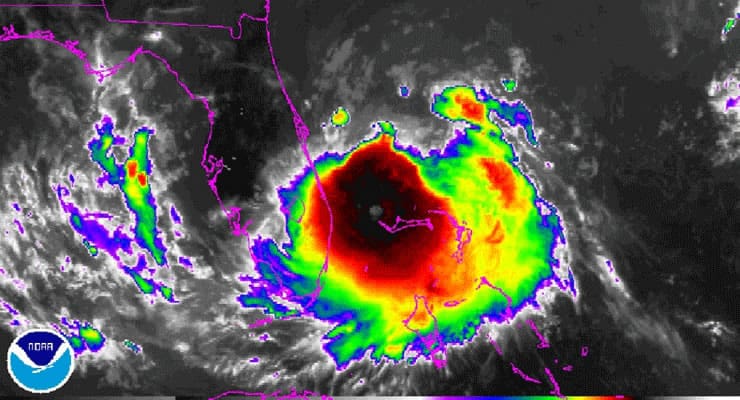
 With maximum sustained winds of 60 mph Wednesday afternoon, Tropical Storm Arthur was centered about 105 miles east-north-east of Cape Canaveral Florida, according to the National Hurricane Center.
The NHC said, Arthur will be steered northward for the next day or so due to a middle/upper level trough over the mid-Atlantic states and a subtropical ridge east of the Carolinas.
As of 2:00 p.m., Wednesday, Arthur is forecast to become a hurricane Thursday.
Meanwhile hurricane watches and tropical storm warning were issued today for parts of North Carolina, just in time to put a damper on your plans for July 4.
The center of the first tropical storm of the 2014 season was expected to stay offshore of Florida, then move northward and parallel the Carolina coast.
From the Florida Division of Emergency Management, most recent update: Wednesday, July 2, 2014, 9:15 a.m.
Cloud cover and showers will build inland along the Eastern Peninsula today with most places along the spine of the state eastward with higher rain chances in the 40% to 60% range due to tropical storm Arthur churning about 100 miles east of the Florida coastline. This will create a breezy day across Central Florida with winds gusting to 20 to 25 mph at times. Some storms along the peninsula, especially in Brevard and Volusia counties may contain wind gusts in the 30 to 40 mph range. Isolated tornadoes and waterspouts may be a possibility in some of the stronger storms that develop in the feeder bands that rotate onshore.In addition, heavy downpours are possible at times with 1 to 3 inches of rain forecast to fall with isolated amounts of up to 4 inches across East Central Florida.
