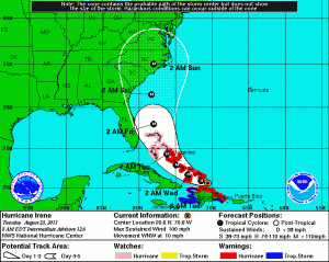
All eyes are on Hurricane Irene as it strengthened to a category 2 hurricane Monday evening and has since maintained that strength.
On Tuesday morning Irene was lashing the northern coast of the Dominican Republic and is expected to move over the Turks and Caicos Islands later Tuesday with top winds of 100 miles per hour.
Irene is forecast to become a major hurricane with wind speeds higher than 111 mph by Tuesday night.
A hurricane watch is in effect for the north coast of Haiti from Le Mole St. Nicholas eastward to the Dominican Republic border and the Northwest Bahamas.
According to the current forecast, Irene will reach the Central Bahamas Wednesday and the Northwest Bahamas Thursday.
Forecasters say, after departing the Northwest Bahamas early Friday, Irene should parallel the Florida coast later Friday and approach the coast of the Carolinas later Saturday or Saturday morning.
Even though Irene is expected to skirt Florida on its current path, it is a larger-than-average hurricane, so the state will still have some impacts. Heavy rain and strong winds are likely in eastern portions of Florida beginning late Wednesday night in southeast areas and spreading northward through Friday, forecasters say.
Florida residents and visitors are being warned of dangerous surf and rip currents likely along the east coast later Wednesday and lasting into the weekend. These coastal threats will expand northward along the Eastern Seaboard during the weekend and early next week.


