Brevard County prepared for the NASA Artemis II launch at Kennedy Space Center in Central Florida, and a local traffic flow map was released.
Artemis II is the first crewed launch of NASA’s SLS (Space Launch System) rocket and Orion spacecraft, and it is on a mission to the Moon. The countdown for NASA’s Artemis II test flight is underway at the agency’s Kennedy Space Center in Central Florida, with a targeted launch time of 6:24pm on Wednesday, April 1st.
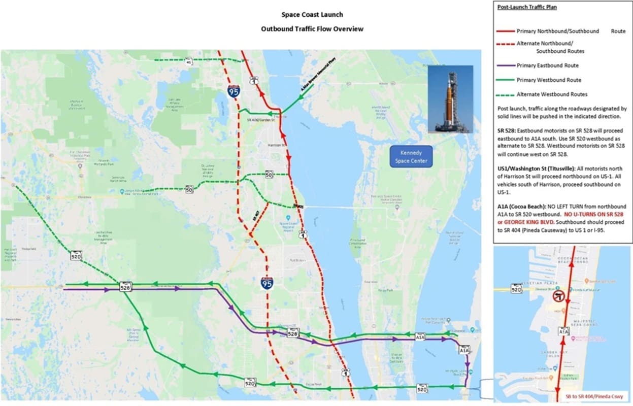
Officials warned the community to expect heavy traffic before and after the launch, and issued a traffic flow overview:
There will be active monitoring of major intersections to assist with traffic flow, and FDOT teams will be in the area and deploying additional Road Rangers along I-95 and S.R. 528 for motorist assistance.
Post-launch traffic guidance included:
- If you are near the A. Max Brewer Bridge, please travel north on S. Washington Avenue (US1) to Mims, then take SR 46 west to I95
- If you are north of Harrison Street, please use SR 406 (Garden Street) to I-95 or North on Washington Avenue (US1) to Mims for SR46.
- If you are south of Harrison Street, please use SR50 (Cheney Highway) to I95 or SR 405 (Columbia Blvd) to SR407 (Challenger Memorial Parkway)
- Another option, travel south on S Washington Avenue (US1) to the city of Cocoa, to the entrance to SR528 (Beachline Expressway)
- There will be no U-turns on SR 528 or George King Blvd. after the launch.
- The A. Max Brewer Bridge may be closed to vehicle traffic as a precaution to pedestrian safety, according to law enforcement, and it will reopen after the launch once pedestrian traffic has cleared.
Law enforcement partners across Brevard County will also have an increased presence across the Space Coast. Expecting a large influx of visitors, the Titusville Police Department will have an increased presence throughout the city to ensure the safety of all residents and guests. Additional personnel will include officers from patrol, traffic units, SWAT, SROs, detectives, bicycle units, and drone teams, all working together to support public safety during this event.
Tips for commuters and motorists from Brevard County included:
- If you live or work in the north, central, and beachside areas, plan accordingly and stay off the roadways if possible to avoid traffic congestion.
- If you must travel along these corridors, please plan for extra commute time.
- Consider running errands over the weekend before the launch to avoid traffic.
- Always watch for and yield to pedestrians/bicyclists crossing. There will be heavy foot traffic, especially along US 1/A1A.
- Obey all traffic laws. Do not run red lights, speed, or drive distracted.
- Once the launch is completed traffic will be funneled from East on SR 528 to A1A South and then to SR 520.
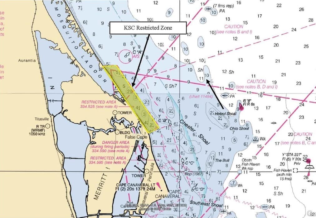
The U.S. Coast Guard and Space Launch Delta 45 have provided guidance maps and observation locations for boaters in the area hoping to view the Artemis launch. Port Canaveral stated that in conjunction with NASA’s Artemis II launch scheduled for April 1st, the Kennedy Space Center Director activated 33 CFR 334.525, KSC Restricted Area, for boaters effective through April 26, 2026, extending approximately 1.5 nautical miles from the KSC. The United States Coast Guard will be broadcasting via VHF 16 and 22 marine channels.
 Officials also reminded that many local parks are closed overnight from dusk to dawn, so plan accordingly. The Space Coast Office of Tourism has an Artemis II webpage with resources including launch locations, traffic maps, boater maps, and hotel information. You can also check Brevard County Emergency Management on Facebook and X.
Local officials also said the Artemis II launch will be loud.
RELATED: Artemis II Ready to Launch at NASA’s Kennedy Space Center
